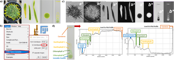
Browse Articles

Flight paths over greenspace in major United States airports

Lee et al. | Sep 26, 2023

Flight paths over greenspace in major United States airports
Image credit: Mostafijur Rahman Nasim

Greenspaces (urban and wetland areas that contain vegetation) are beneficial to reducing pollution, while airplanes are a highly-polluting method of transportation. The authors examine the intersection of these two environmental factors by processing satellite images to reveal what percentage of flight paths go over greenspaces at major US airports.

Read More...

Identifying Neural Networks that Implement a Simple Spatial Concept

Zirvi et al. | Sep 13, 2022

Identifying Neural Networks that Implement a Simple Spatial Concept

Modern artificial neural networks have been remarkably successful in various applications, from speech recognition to computer vision. However, it remains less clear whether they can implement abstract concepts, which are essential to generalization and understanding. To address this problem, the authors investigated the above vs. below task, a simple concept-based task that honeybees can solve, using a conventional neural network. They found that networks achieved 100% test accuracy when a visual target was presented below a black bar, however only 50% test accuracy when a visual target was presented below a reference shape.

Read More...

Enhanced brain arteries and aneurysms analysis using a CAE-CFD approach

Saravanan et al. | Mar 02, 2025

Enhanced brain arteries and aneurysms analysis using a CAE-CFD approach
Image credit: Vineet Saravanan

Here, recognizing that brain aneurysms pose a severe threat, often misdiagnosed and leading to high mortality, particularly in younger individuals, the authors explored a novel computer-aided engineering approach. They used magnetic resonance angiography images and computational fluid dynamics, to improve aneurysm detection and risk assessment, aiming for more personalized treatment.

Read More...

Motion tracking and analysis of spray water droplets studied by high-speed photography using an iPhone X

Geng et al. | Sep 11, 2021

Motion tracking and analysis of spray water droplets  studied by high-speed photography using an iPhone X

Smartphones are not only becoming an inseparable part of our daily lives, but also a low-cost, powerful optical imaging tool for more and more scientific research applications. In this work, smartphones were used as a low-cost, high-speed, photographic alternative to expensive equipment, such as those typically found in scientific research labs, to accurately perform motion tracking and analysis of fast-moving objects. By analyzing consecutive images, the speed and flight trajectory of water droplets in the air were obtained, thereby enabling us to estimate the area of the water droplets landing on the ground.

Read More...

Analysis of the Exoplanet HD 189733b to Confirm its Existence

Babaria et al. | Sep 21, 2020

Analysis of the Exoplanet HD 189733b to Confirm its Existence

In this study, the authors study features of exoplanet 189733 b. This exoplanet, or planets that orbit stars other than the Sun, is found in the HD star system. Using a DSLR camera, they constructed a high caliber exoplanet transit detection tracker to study the orbital periods, radial velocity, and photometry of 189733 b. They then compared results from their system to data collected by other high precision studies. What they found was that their system produced results supporting previously published studies. These results are exciting results from the solar system demonstrating the importance of validating radial velocity and photometry data using high-precision studies.

Read More...

Assessing the association between developed surface area and land surface temperature of urban areas

Ustin et al. | Nov 11, 2024

Assessing the association between developed surface area and land surface temperature of urban areas
Image credit: The authors

Almost all urban areas face the challenge of urban heat islands, areas with substantially hotter land surface temperatures than the surrounding rural areas. These areas are associated with worse air and water
quality, increased power outages, and increased heat-related illnesses. To learn more about these areas, Ustin et al. analyze satellite images of Cleveland neighborhoods to find out if there is a correlation between surface area development and surface temperature.

Read More...

Identifying shark species using an AlexNet CNN model

Sarwal et al. | Sep 23, 2024

Identifying shark species using an AlexNet CNN model

The challenge of accurately identifying shark species is crucial for biodiversity monitoring but is often hindered by time-consuming and labor-intensive manual methods. To address this, SharkNet, a CNN model based on AlexNet, achieved 93% accuracy in classifying shark species using a limited dataset of 1,400 images across 14 species. SharkNet offers a more efficient and reliable solution for marine biologists and conservationists in species identification and environmental monitoring.

Read More...

A HOG feature extraction and CNN approach to Parkinson’s spiral drawing diagnosis

Tripathi et al. | Aug 09, 2024

A HOG feature extraction and CNN approach to Parkinson’s spiral drawing diagnosis

Parkinson’s disease (PD) is a prevalent neurodegenerative disorder in the U.S., second only to Alzheimer’s disease. Current diagnostic methods are often inefficient and dependent on clinical exams. This study explored using machine and deep learning to enhance PD diagnosis by analyzing spiral drawings affected by hand tremors, a common PD symptom.

Read More...