Image credit: Meister, Horvath, and Brown de Colstoun
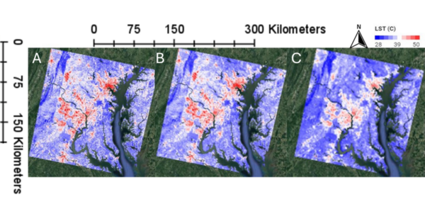
This manuscript investigates the urban heat island (UHI) effect by utilizing two satellite datasets: Landsat (high spatial resolution, lower temporal resolution) and MODIS (lower spatial resolution, high temporal resolution). The authors hypothesized that Landsat would provide better spatial detail, while MODIS would better capture temporal variations. Their analysis in the Washington D.C.–Baltimore region supports these hypotheses, demonstrating that Landsat offers finer spatial details, whereas MODIS provides more consistent seasonal patterns and better detects heatwave frequencies.
In this study, the authors use aerosol optical depth data to determine if aerosol levels were lower in major metropolitan areas around the world during the COVID-19 pandemic.
The sugar-rich modern diet underlies a suite of metabolic disorders, most common of which is diabetes. Accurately reporting the sugar content of pre-packaged food and drink items can help consumers track their sugar intake better, facilitating more cognisant and, eventually, moderate consumption of high-sugar items. In this article, the authors examine the effect of several variables on the accuracy of Fehling's reaction, a colorimetric reaction used to estimate sugar content.
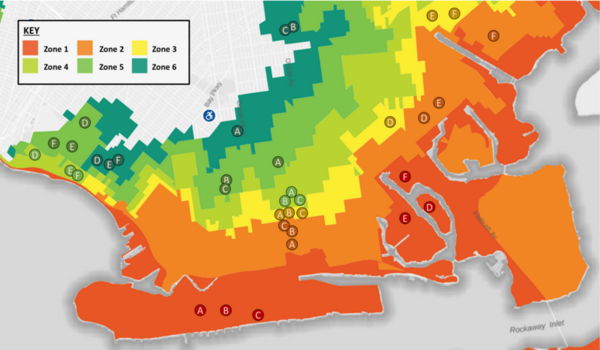
With climate change and rising sea levels, south Brooklyn is exposed to massive flooding and intense precipitation. Previous research discovered that flooding shifts plant species distribution, decreases soil pH, and increases salt concentration, nitrogen, phosphorus, and potassium levels. The authors predicted a decreasing trend from Zone 1 to 6: high-pH, high-salt, and high-nutrients in more flood-prone areas to low-pH, low-salt, and low-nutrient in less flood-prone regions. They performed DNA barcoding to identify plant species inhabiting flood zones with expectations of decreasing salt tolerance and moisture uptake by plants' soil from Zones 1-6. Furthermore, they predicted an increase in invasive species, ultimately resulting in a decrease in biodiversity. After barcoding, they researched existing information regarding invasiveness, ideal soil, pH tolerance, and salt tolerance. They performed soil analyses to identify pH, nitrogen (N), phosphorus (P), and potassium (K) levels. For N and P levels, we discovered a general decreasing trend from Zone 1 to 6 with low and moderate statistical significance respectively. Previous studies found that soil moisture can increase N and P uptake, helping plants adopt efficient resource-use strategies and reduce water stress from flooding. Although characteristics of plants were distributed throughout all zones, demonstrating overall diversity, the soil analyses hinted at the possibility of a rising trend of plants adapting to the increase in flooding. Future expansive research is needed to comprehensively map these trends. Ultimately, investigating trends between flood zones and the prevalence of different species will assist in guiding solutions to weathering climate change and protecting biodiversity in Brooklyn.
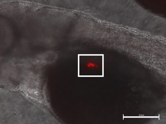
Alcohol is known to cause various developmental diseases including Fetal Alcohol Syndrome. Here the authors investigate the effect of ethanol on the development of zebrafish beta cells, the part of the pancreas associated with Type 1 Diabetes. They find that exposure to ethanol does adversely affect beta-cell development, suggesting that alcohol ingestion during pregnancy may be linked to diabetes in newborns.
This study contributes to our understanding of how urban energy systems respond to climate variability and inform strategies for enhancing power grid resilience. The findings can help inform urban planners and infrastructure developers by identifying the factors that make regions within a power grid more vulnerable.
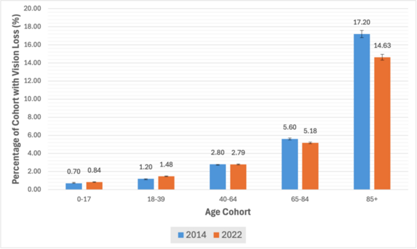
This study examined how social determinants of health (SDH) relate to vision loss by analyzing publicly available data from 18 northern and southern U.S. states and using Bayesian correlation analysis.
Almost all urban areas face the challenge of urban heat islands, areas with substantially hotter land surface temperatures than the surrounding rural areas. These areas are associated with worse air and water
quality, increased power outages, and increased heat-related illnesses. To learn more about these areas, Ustin et al. analyze satellite images of Cleveland neighborhoods to find out if there is a correlation between surface area development and surface temperature.