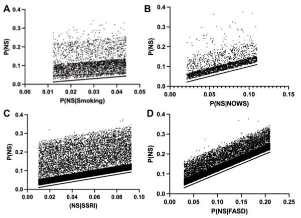
People are quick to accept the assumption that a light will appear dimmer the farther away they are, citing the inverse square relationship that illuminance obeys as rationale. However, repeated observations of light sources maintaining their brightness over large distances prompted us to explore how the brightness, or perceived illuminance of a light varies with the viewing distance from the object. We hypothesized that since both the illuminance of the light source and image size decrease at the same rate, then the concentration, or intensity of the image remains unchanged, and subsequently the perceived illuminance.
Triggered largely by the warming and pollution of oceans, corals are experiencing bleaching and a variety of diseases caused by the spread of bacteria, fungi, and viruses. Identification of bleached/diseased corals enables implementation of measures to halt or retard disease. Benthic cover analysis, a standard metric used in large databases to assess live coral cover, as a standalone measure of reef health is insufficient for identification of coral bleaching/disease. Proposed herein is a solution that couples machine learning with crowd-sourced data – images from government archives, citizen science projects, and personal images collected by tourists – to build a model capable of identifying healthy, bleached, and/or diseased coral.
Smartphones are not only becoming an inseparable part of our daily lives, but also a low-cost, powerful optical imaging tool for more and more scientific research applications. In this work, smartphones were used as a low-cost, high-speed, photographic alternative to expensive equipment, such as those typically found in scientific research labs, to accurately perform motion tracking and analysis of fast-moving objects. By analyzing consecutive images, the speed and flight trajectory of water droplets in the air were obtained, thereby enabling us to estimate the area of the water droplets landing on the ground.
In this study the authors develop an app for faster chess game entry method to help chess learners improve their game. This culminated in the Augmented Reality Chess Analyzer (ARChessAnalyzer) which uses traditional image and vision techniques for chess board recognition and Convolutional Neural Networks (CNN) for chess piece recognition.
There are believed to be ~20,000 nebulae in the Milky Way Galaxy. However, humans have only cataloged ~1,800 of them even though we have gathered 1.3 million nebula images. Classification of nebulae is important as it helps scientists understand the chemical composition of a nebula which in turn helps them understand the material of the original star. Our research on nebulae classification aims to make the process of classifying new nebulae faster and more accurate using a hybrid of deep learning and machine learning techniques.
Here, recognizing the potential harmful effects of algal blooms, the authors used satellite images to detect algal blooms in water bodies in Wyoming based on their reflectance of near infrared light. They found that remote monitoring in this way may provide a useful tool in providing early warning and advisories to people who may live in close proximity.
With climate change and rising sea levels, south Brooklyn is exposed to massive flooding and intense precipitation. Previous research discovered that flooding shifts plant species distribution, decreases soil pH, and increases salt concentration, nitrogen, phosphorus, and potassium levels. The authors predicted a decreasing trend from Zone 1 to 6: high-pH, high-salt, and high-nutrients in more flood-prone areas to low-pH, low-salt, and low-nutrient in less flood-prone regions. They performed DNA barcoding to identify plant species inhabiting flood zones with expectations of decreasing salt tolerance and moisture uptake by plants' soil from Zones 1-6. Furthermore, they predicted an increase in invasive species, ultimately resulting in a decrease in biodiversity. After barcoding, they researched existing information regarding invasiveness, ideal soil, pH tolerance, and salt tolerance. They performed soil analyses to identify pH, nitrogen (N), phosphorus (P), and potassium (K) levels. For N and P levels, we discovered a general decreasing trend from Zone 1 to 6 with low and moderate statistical significance respectively. Previous studies found that soil moisture can increase N and P uptake, helping plants adopt efficient resource-use strategies and reduce water stress from flooding. Although characteristics of plants were distributed throughout all zones, demonstrating overall diversity, the soil analyses hinted at the possibility of a rising trend of plants adapting to the increase in flooding. Future expansive research is needed to comprehensively map these trends. Ultimately, investigating trends between flood zones and the prevalence of different species will assist in guiding solutions to weathering climate change and protecting biodiversity in Brooklyn.
Intelligent vehicles utilize a combination of video-enabled object detection and radar data to traverse safely through surrounding environments. However, since the most momentary missteps in these systems can cause devastating collisions, the margin of error in the software for these systems is small. In this paper, we hypothesized that a novel object detection system that improves detection accuracy and speed of detection during adverse weather conditions would outperform industry alternatives in an average comparison.
Semantic segmentation - labelling each pixel in an image to a specific class- models require large amounts of manually labeled and collected data to train.
There are two types of competing TV screens on the market, organic light emitting diode (OLED) and liquid crystal display (LCD). The better capability to exhibit black results in higher contrast images. Here, authors compared the ability of the two types of screens to show black in an environment eliminating external light.