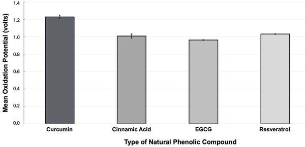
The authors looked at the potential of different phenolic compounds to reduce oxidative stress (i.e., act as antioxidants).
Read More...The effect of natural phenolic compounds on reducing oxidative stress
The authors looked at the potential of different phenolic compounds to reduce oxidative stress (i.e., act as antioxidants).
Read More...A five-year retrospective analysis of Tuberculosis risk factors and their variability in the United States
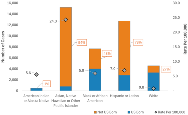
The main goal of this study is to determine what demographics are related to tuberculosis incidence in the United States populations, particularly if changing demographics are related to differences in tuberculosis risk over two discrete time periods. The major finding is that in the two studied time periods, tuberculosis risk factors were somewhat consistent and may be influenced by things such as immigration, healthcare access, and race or ethnicity, although the top predictor did change.
Read More...Mendelian randomization reveals shared genetic landscape in autism spectrum disorder and Alzheimer's disease
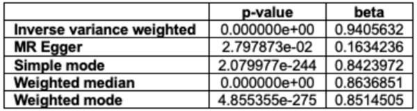
Autism Spectrum Disorder (ASD) and Alzheimer's Disease (AD) are distinct conditions, but research suggests a link, as individuals with ASD are 2.5 times more likely to develop AD. A study employing genome-wide association studies and Mendelian randomization revealed shared genetic factors, particularly in synaptic regulation pathways, that may increase the risk of AD in those with ASD. These findings provide insights into the genetic underpinnings connecting the two disorders.
Read More...A novel approach for predicting Alzheimer’s disease using machine learning on DNA methylation in blood

Here, recognizing the difficulty associated with tracking the progression of dementia, the authors used machine learning models to predict between the presence of cognitive normalcy, mild cognitive impairment, and Alzheimer's Disease, based on blood DNA methylation levels, sex, and age. With four machine learning models and two dataset dimensionality reduction methods they achieved an accuracy of 53.33%.
Read More...Toxicity of aminomethylphosphonic acid via the Wnt signaling pathway as a novel mechanism

The Wnt signaling pathway, known to coordinate important aspects of cellular homeostasis ranging from differentiation, proliferation, migration, and much more, is dysregulated in many human diseases. This study demonstrates that aminomethylphosphonic acid, which is the main metabolite found in the common herbicide Glyphosate, is toxic to planaria and capable of binding to canonical Wnt proteins.
Read More...The effects of stress on the bacterial community associated with the sea anemone Diadumene lineata

In healthy ecosystems, organisms interact in a relationship that helps maintain one another's existence. Stress can disrupt this interaction, compromising the survival of some of the members of such relationships. Here, the authors investigate the effect of stress on the interaction between anemones and their microbiome. Their study suggests that stress changes the composition of the surface microbiome of the anemone D. lineata, which is accompanied by an increase in mucus secretion. Future research into the composition of this stress-induced mucus might reveal useful antimicrobial properties.
Read More...The Effect of Different Fructose Diets on the Lifespan of C. elegans

High-fructose diets consumed widely in modern societies predisposes to metabolic diseases such as diabetes. Using the worm C. elegans, the authors of this study investigated the effect of fructose on the worm's survival rates. They found that worms fed 15% fructose had a lower life expectancy than those on a fructose-free diet. These results suggest that, like in humans, fructose has a negative effect on worm survival, which makes them an easy, attractive model to study the effects of fructose on health.
Read More...Behavioral Longevity: The Impact of Smoking, Alcohol Consumption, and Obesity on Life Expectancy
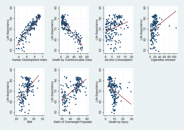
In this article, the authors look into what is already known about the factor affecting longevity and determine the importance of behavioral factors including alcohol consumption, smoking, and obesity on longevity. The authors quantify data from over 150 countries and, interestingly, find that the impact each factor has on longevity is at least in part dependent on the country's economic development status. Overall, they conclude that an average person’s life expectancy can increase by more than 3 years if smoking and alcohol consumption is reduced by a half and weight is decreased by 10%.
Read More...TGFβ1 Codon 10 Polymorphism and its Association with the Prevalence of Low Myopia
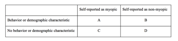
The goal of this project was to assess the relationships among low myopia, behavioral and demographic factors, and a single-nucleotide polymorphism (SNP) in the TGFβ1 gene.
Read More...The Effect of the Stomatal Index on the Net Rate of Photosynthesis in the Leaves of Spinacia oleracea, Vinca minor, Rhododendron spp, Epipremnum aureum, and Hedera spp
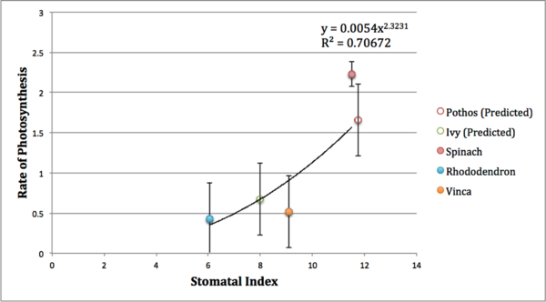
The density of stomata, or stomatal index, in plant leaves is correlated with the plant's rate of photosynthesis, and affected by the plant's climate. In this paper, authors measure the stomatal index of five plant species to derive their rates of photosynthesis. These results could help track changes in plants' photosynthetic rates with changing climate.
Read More...