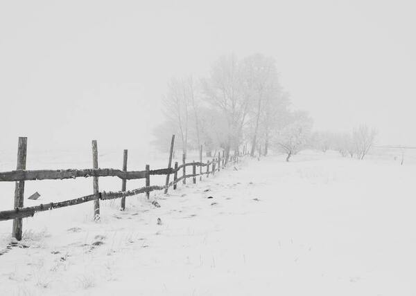
Here, in an effort to develop a model to predict future groundwater levels, the authors tested a tree-based automated artificial intelligence (AI) model against other methods. Through their analysis they found that groundwater levels in Texas aquifers are down significantly, and found that tree-based AI models most accurately predicted future levels.
Here the authors sought to understand the effects of different variables that may be tied to pollution and climate change on genetic variation of Pacific white-sided dolphins, a species that is currently threatened by water pollution. Based on environmental data collected alongside a genetic distance matrix, they found that ocean currents had the most significant impact on the genetic diversity of Pacific white-sided dolphins along the Japanese coast.
With climate change and rising sea levels, south Brooklyn is exposed to massive flooding and intense precipitation. Previous research discovered that flooding shifts plant species distribution, decreases soil pH, and increases salt concentration, nitrogen, phosphorus, and potassium levels. The authors predicted a decreasing trend from Zone 1 to 6: high-pH, high-salt, and high-nutrients in more flood-prone areas to low-pH, low-salt, and low-nutrient in less flood-prone regions. They performed DNA barcoding to identify plant species inhabiting flood zones with expectations of decreasing salt tolerance and moisture uptake by plants' soil from Zones 1-6. Furthermore, they predicted an increase in invasive species, ultimately resulting in a decrease in biodiversity. After barcoding, they researched existing information regarding invasiveness, ideal soil, pH tolerance, and salt tolerance. They performed soil analyses to identify pH, nitrogen (N), phosphorus (P), and potassium (K) levels. For N and P levels, we discovered a general decreasing trend from Zone 1 to 6 with low and moderate statistical significance respectively. Previous studies found that soil moisture can increase N and P uptake, helping plants adopt efficient resource-use strategies and reduce water stress from flooding. Although characteristics of plants were distributed throughout all zones, demonstrating overall diversity, the soil analyses hinted at the possibility of a rising trend of plants adapting to the increase in flooding. Future expansive research is needed to comprehensively map these trends. Ultimately, investigating trends between flood zones and the prevalence of different species will assist in guiding solutions to weathering climate change and protecting biodiversity in Brooklyn.
Growing climate concerns have intensified research into zero-emission transportation fuels, notably hydrogen. Hydrogen is considered a clean fuel because its only major by-product is water. This project analyzes how hydrogen compares to kerosene as a commercial aircraft fuel with respect to cost, CO2 emissions, and flight range.
Here recognizing the potential for pollution to impact the ecosystems of local waterways, the authors investigated the growth of tiger lilies, which are invasive to the Potomac River, in relation to the level of pollution. The authors report that increasing levels of pollution led to increased growth of the invasive species based on their study.
Understanding the relationships between temperature, MEI, SPI, and CO2 concentration is important as they measure the major influencers of California’s regional climate: temperature, ENSO, precipitation, and atmospheric CO2. In this article, the authors analyzed temperature, Multivariate El Niño-Southern Oscillation Index (MEI), and Standard Precipitation Index (SPI) data from the San Francisco Bay Area from 1971 to 2016. They also analyzed CO2 records from Mauna Loa, HI for the same time period, along with the annual temperature anomalies for the Bay Area.
A key barrier to adoption of solar energy technology is the low efficiency of solar cells converting solar energy into electricity. Sims and Sims tackle this problem by coding a Raspberry Pi as a multimeter to determine which wavelength of light generates the most voltage and current from a solar panel.
Coral bleaching is a fatal process that reduces coral diversity, leads to habitat loss for marine organisms, and is a symptom of climate change. This process occurs when corals expel their symbiotic dinoflagellates, algae that photosynthesize within coral tissue providing corals with glucose. Restoration efforts have attempted to repair damaged reefs; however, there are over 360,000 square miles of coral reefs worldwide, making it challenging to target conservation efforts. Thus, predicting the likelihood of bleaching in a certain region would make it easier to allocate resources for conservation efforts. We developed a machine learning model to predict global locations at risk for coral bleaching. Data obtained from the Biological and Chemical Oceanography Data Management Office consisted of various coral bleaching events and the parameters under which the bleaching occurred. Sea surface temperature, sea surface temperature anomalies, longitude, latitude, and coral depth below the surface were the features found to be most correlated to coral bleaching. Thirty-nine machine learning models were tested to determine which one most accurately used the parameters of interest to predict the percentage of corals that would be bleached. A random forest regressor model with an R-squared value of 0.25 and a root mean squared error value of 7.91 was determined to be the best model for predicting coral bleaching. In the end, the random model had a 96% accuracy in predicting the percentage of corals that would be bleached. This prediction system can make it easier for researchers and conservationists to identify coral bleaching hotspots and properly allocate resources to prevent or mitigate bleaching events.
In this study, the authors address the current climate concern of high CO2 levels by testing solid forms of hydroxide for CO2 reduction and designing a drone to fly it in ambient air!